Moving at a Turtle's Pace
- brianprivett
- Jan 19
- 5 min read
Sheltowee Trace Sections 1 & 2 (Northern Terminus to Morehead Convention Center)

Every year, the Sheltowee Trace Association holds a Hiker Challenge where participants can finish the entire 343 miles of the Trace in sections over 11 months, one weekend a month. The Trace is a National Recreation Trail that runs from north of Morehead through the length of the Daniel Boone National Forest, down into Tennessee and shares the name the Shawnee gave to Daniel Boone, Sheltowee, which means "Big Turtle".

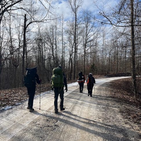
This past weekend was the first trip for year and I was one of around 75 people that slowly made our way from the Northern Terminus into Downtown Morehead on a frigid weekend with snow. Cold, yes. Legs burning, yes. Ready for the next section? Absolutely.
This is not meant to give any kind of advice or note and waypoints on the trail, so please buy the official Sheltowee Trace Association map on FarOut here.

First section was from the Northern Terminus about 18 miles from Morehead to a campsite where the trail crossed Holly Fork Road, a hike of 11.4 miles. From the terminus, the trail climbs straight uphill for about 350 feet over .8 miles to get to the top of a ridge where the trail stays most of the time over this stretch. The trail has steady up and down until it drops down to hollow at Clark Farm, a private stop where a family has a shelter and some port-a-johns. I'm not sure if these are public facilities, so you better check before you pitch a tent.
From Clark Farm, it's back up to the top of the ridge another couple of miles until you come down to Holly Fork Road where there's a large campsite.

We started at about 8 am on Saturday morning and had about an inch of snow on the ground and 24 degrees. It would get to a high in the mid-30's that day, a pretty sweat-free day of hiking even with the frequent up and downs along and between ridges.
Here's the thing about this section of trail. There's not much to see. You go up on the ridge in mature woods and you stay in those woods with no vistas or lookouts or anything really to look at other than down at the trail for the next 9 miles. Of course it's the DBNF, so it's gorgeous and peaceful and the geology is ancient, but be prepared to walk with your head down for most of the time. Sing songs in your head. Or have some conversationalists to hike with.

Section Two starts at Holly Fork Road, across what was described to me as "the sketchiest bridge on the trail." If that's the worst bridge on the trail, I feel pretty safe for the future. After walking past a field of not very curious cows, you go straight up another 400 feet or so to the top of the ridge, then hike on to the Morehead Convention Center, a stretch of 14 miles.
After hiking the top of the ridge for a couple of miles, the trail veers off onto a paved county road for about 200 yards, crossing above I-64, then immediately turning right onto a gravel forest service road.
You will follow this road for about 6 miles and if you thought you had little to see on section one, this road walk will make you wish for more trees or mushrooms or maybe, as one of the hikers with us suggested, signs with trivia questions followed by a sign with the answer further down the road. Something at least. Most we got was a surprised bicyclist going the opposite way.
This is the stretch where your legs will stiffen, too, because all those ridge climbing muscles in your thighs will take a nap on the road while your feet just keep marching. Soldier on.


Don't worry, though, your legs will wake up soon. The next section when you leave the road is called the "bunny hops" - a 4 miles up and down stretch of 250 feet straight up, then straight down, over and over until you want to just drop off the ridge and call for rescue to come get you. I swear at some point I think I hit a glitch in time/space because I know I did the same ridges four or five times over. There again is not much to look at here other than trees and the rise in the trail up ahead that WILL make you say, "holy $*&@, another one?" When I got off the trail, the best way to describe that section is "those bunny hops are stupid". And they are.

There are a few places where clearance for electric lines give you some good vistas, but on a cold, winter day, I noticed mostly lots of chestnut oak leaves and acorns on the ground. When we started the morning it was 17 degrees and it hit a high of 24 that day. My water never froze completely, just got slushy and cold and fun.

When you finally hit the narrow switchbacks to go down into Morehead, there are some nice overlooks and then you're down to Eagle Lake on the backside of Morehead State University campus. You cross through campus, following the white turtle blazes on the sidewalks until you take a right onto Main Street and head through downtown Morehead.
Overall, don't walk this section if you're not dedicated to finishing the Sheltowee at some point in your life. There's some tough sections for your quads and knees and not much payoff in attractions like overlooks or interesting rocks or cliffs or arches.
Morehead has embraced the ST coming through town and have turtle art and shops geared toward trail users that seems like a nice place to lounge. When I got down from those stupid bunny hops, though, and got to the car, I turned the heat on full blast, drove straight toward the McDonalds a mile away and got the No. 7 two cheeseburger value meal, 2 Diet Cokes, a medium chocolate shake. I drove straight home ready to come back next month to start the next section.
Sheltowee Trace:
Section One: Northern Terminus to Holly Fork Road: 11.4 miles
Section Two: Holly Fork Road to Morehead Convention Center: 14.0 miles
Brian Privett is a back-of-the-pack hiker from Paris, Kentucky that would be known as "Slow White Turtle" if adopted by the Shawnee. He overpacks, stops for rocks, is not afraid of bridges, and had Wilco's "Jesus, Etc." stuck in his head most of this hike.


Comments